


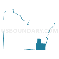
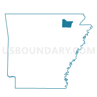
DOWELL Voting District, Lawrence County, Arkansas
About
Outline

Summary
| Unique Area Identifier | 527067 |
| Name | DOWELL Voting District |
| County | Lawrence County |
| State | Arkansas |
| Area (square miles) | 31.26 |
| Land Area (square miles) | 31.26 |
| Water Area (square miles) | 0.00 |
| % of Land Area | 100.00 |
| % of Water Area | 0.00 |
| Latitude of the Internal Point | 35.92232640 |
| Longtitude of the Internal Point | -90.92844450 |
Maps

Graphs
Select a template below for downloading or customizing gragh for DOWELL Voting District, Lawrence County, Arkansas


Neighbors
Neighoring Voting District (by Name) Neighboring Voting District on the Map
- ASHLAND Voting District, Lawrence County, AR
- Big Creek Voting District, Craighead County, AR
- BOAS 3 HOXIE Voting District, Lawrence County, AR
- Jonesboro PCT 7 North, Craighead County, AR
- MARION Voting District, Lawrence County, AR
- Promised Land Voting District, Craighead County, AR
- PROMISED LAND Voting District, Lawrence County, AR
Top 10 Neighboring County Subdivision (by Population) Neighboring County Subdivision on the Map
- Jonesboro township, Craighead County, AR (54,649)
- Big Creek township, Craighead County, AR (5,277)
- Boas township, Lawrence County, AR (2,963)
- Promised Land township, Lawrence County, AR (425)
- Marion township, Lawrence County, AR (328)
- Dowell township, Lawrence County, AR (291)
- Ashland township, Lawrence County, AR (240)
- Promised Land township, Craighead County, AR (190)